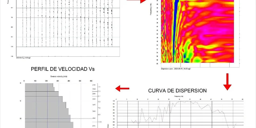
Longueuil sits at just 12 meters above the St. Lawrence River, on a complex sedimentary basin where the post-glacial Champlain Sea left deposits of sensitive marine clay. The 2013 revision to the National Building Code of Canada (NBCC) made seismic site classification mandatory for most structures, and for good reason—the soft Leda clay layers common across the South Shore can amplify ground motion significantly during an event. A MASW survey delivers the VS30 profile needed to assign Site Class C, D, or E under NBCC Table 4.1.8.4.A without the cost and disturbance of deep boreholes. Our crew runs the full acquisition and inversion workflow within a day on standard lots in Vieux-Longueuil and Greenfield Park, then processes the dispersion curves using an ISO 17025-accredited procedure that holds up under peer review. For deeper bedrock targets near the RCM of Longueuil’s industrial zones, we often pair the surface wave data with a targeted CPT test to calibrate the upper 20 meters against a direct measurement.
A MASW survey delivers the VS30 profile required under NBCC 2015 without drilling through sensitive Leda clay—saving time and reducing site disturbance.
Frequently asked questions
How much does a MASW survey cost for a single-family lot in Longueuil?
For a standard residential lot in Longueuil, a complete MASW survey with VS30 calculation and an NBCC site class letter typically runs between CA$2,030 and CA$3,990. The range depends on access constraints, the need for extended spreads to reach deeper bedrock, and whether complementary seismic refraction is added to constrain the velocity model.
What seismic site class does Longueuil generally fall into under the NBCC?
Most of Longueuil falls into Site Class D or E depending on the thickness of the Champlain Sea clay. Neighborhoods like Vieux-Longueuil and LeMoyne with 18 to 25 meters of soft clay often classify as Site E (VS30 below 180 m/s). Areas around Saint-Hubert and Greenfield Park with shallower till or sandier deposits more commonly reach Site Class D (180 to 360 m/s). A site-specific MASW survey is the only reliable way to assign the class for permit submission.
Can you run a MASW survey in winter when the ground is frozen?
Winter surveys are possible but require caution. Frozen ground creates a high-velocity crust that biases the dispersion curve above 15–20 Hz. We apply a seasonal correction based on local South Shore experience and, where the budget allows, run a parallel CPT test to independently verify the shallow shear strength. That said, we strongly recommend scheduling MASW work between April and November to avoid the frozen-layer ambiguity.