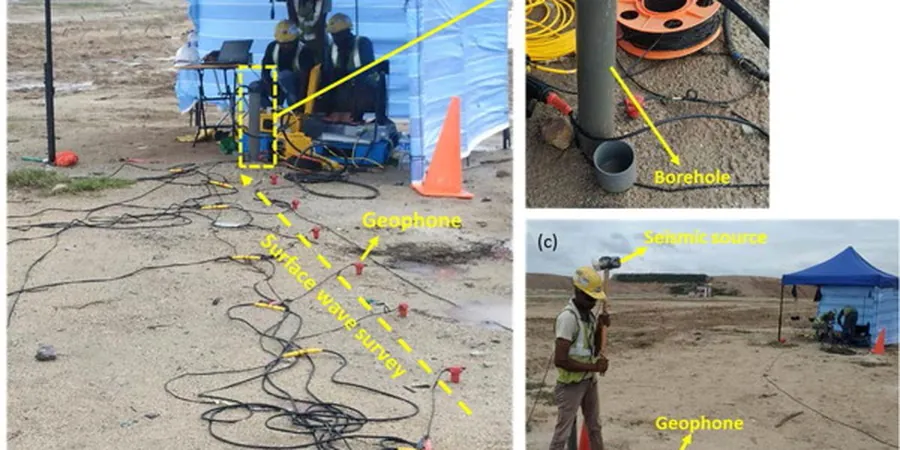
Longueuil sits directly atop the deep, sensitive clays of the Champlain Sea basin, a geological reality that shapes every major construction decision here. The Saint Lawrence River to the north and the Montérégie Hills to the south create a complex subsurface profile where seismic waves don’t behave uniformly. Site amplification can vary dramatically within a few blocks, which is why a city-wide seismic microzonation approach is essential. Our field experience shows that standard code spectra alone can underestimate design accelerations in the eastern plateau areas near Parc Michel-Chartrand. A proper microzonation campaign integrates ambient vibration measurements, borehole shear-wave velocity profiling, and geotechnical laboratory data to produce ground response maps that engineers can actually use. We combine this with MASW surveys to capture continuous Vs profiles, and where site access allows, we complement the work with seismic refraction to constrain bedrock depth across the municipality.
In Longueuil, the thickness of Champlain Sea clay can change by over 15 meters within a single city block, making site-specific ground response analysis indispensable for mid-rise and tall structures.
Local considerations
Longueuil’s population exceeds 250,000, and its critical infrastructure, including the Jacques-Cartier Bridge approach and the Longueuil metro station, sits on soils known for seismic amplification. The 1988 Saguenay earthquake, though centered over 400 km away, produced surprisingly strong ground motions in the Saint Lawrence lowlands due to wave trapping in the sedimentary basin. A microzonation study identifies which neighborhoods face the highest risk of spectral acceleration exceeding code-default values. Without this data, structural designs for schools, hospitals, and residential towers may unknowingly underestimate seismic demands by 20 to 30 percent. The combination of soft clay, variable bedrock topography, and proximity to the seismically active Western Quebec Zone makes ignoring site effects a genuine public safety concern for the city’s long-term resilience planning.
Applicable standards
NBCC 2020 (National Building Code of Canada, Part 4, Division B), CSA A23.3-19 (Design of Concrete Structures, seismic provisions), ASTM D4428 / D5777 (Crosshole and downhole seismic testing), NEHRP site classification methodology (FEMA P-1050), Eurocode 8 adapted for Eastern Canada crustal seismicity (comparative analysis)
Frequently asked questions
How much does a seismic microzonation study cost for a Longueuil project?
For a typical Longueuil site, the cost of a seismic microzonation study ranges from CA$5,320 for smaller, single-building assessments to CA$24,830 for multi-hectare developments or municipal-scale mapping. The final price depends on the grid density, depth of investigation required, and the number of field measurement points needed to capture the lateral variability of the Champlain Sea clays across the site.
How long does a microzonation study take from start to finish?
A typical field campaign in Longueuil requires three to five working days, depending on the area size and access constraints. Laboratory data processing and site response analysis add another three to four weeks. The final report, including Vs30 maps and design spectra, is generally delivered within six weeks of project kickoff, though timelines can adjust for larger municipal-scale studies.
Why can’t we just use the NBCC 2020 site class maps for Longueuil?
The NBCC 2020 provides regional hazard values but cannot capture the fine-scale lateral variability of Longueuil’s Champlain Sea deposits. Clay thickness, shear-wave velocity, and impedance contrasts change rapidly across the city. A site-specific microzonation study resolves these local effects, often revealing amplification factors that differ significantly from the generalized code maps, especially in transition zones between site classes D and E.
What site class does most of Longueuil fall into?
Longueuil’s site classes are highly variable due to the paleo-depositional history of the Champlain Sea. Many areas in central and eastern Longueuil fall into site class D or E, with Vs30 values typically between 150 and 350 m/s. Proximity to bedrock outcrops near the Montérégie Hills pushes some western areas into class C, while deep clay pockets near the Saint Lawrence can approach class F conditions requiring site-specific ground response analysis.