NBCC 2020, reinforced by local amendments, demands clear subsurface imaging in a city like Longueuil where the contact between overburden and bedrock can shift abruptly over short distances. Seismic refraction and reflection tomography answer that need directly: they map the velocity structure of the ground, flagging weak zones, cavities, and the true depth to refusal long before a backhoe ever hits the site. We run these surveys throughout the South Shore, from Vieux-Longueuil to Saint-Hubert, and the data routinely saves projects from costly guesswork. A seismic refraction line can also be paired with a MASW spread on the same layout to pull Vs30 profiles without doubling the field time.
Reflection tomography in the Champlain Sea clays can pick the bedrock reflector within 0.5 m of the cored depth, even where the bedrock surface dips more than 20 degrees.
Local considerations
In Longueuil, we see too many projects where the contractor bid based on a handful of boreholes that hit rock at, say, 8 meters, only to discover a 14-meter-deep trough between the holes once excavation starts. The extra cost of hammering or blasting that volume of rock—plus the delay—eats the contingency in weeks. Seismic tomography catches those troughs because it illuminates the entire section, not just isolated points. Another risk is misclassifying a weathered shale layer as competent bedrock: a velocity of 1,800 m/s excavates with a ripper, while 4,000 m/s requires a hydraulic breaker. The tomography line gives the contractor a rippability map they can actually use to schedule equipment, and that alone usually pays for the survey.
Frequently asked questions
How much does a seismic tomography survey cost in Longueuil?
For a typical refraction line in Longueuil, budgets run between CA$3,930 and CA$7,760 depending on the spread length, number of shots, and whether reflection processing is added. Urban sites with asphalt cutting for geophone planting push toward the upper end. We provide a fixed-price quote after reviewing the site plan and target depth.
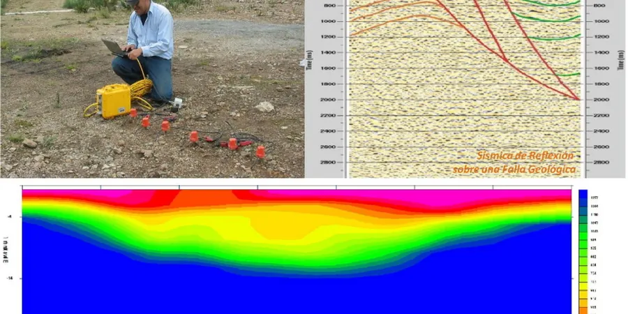
How deep can refraction tomography see in the Longueuil area?
With a 115-meter spread and a weight-drop source, we typically map 25 to 30 meters into the subsurface—enough to reach competent bedrock across most of the city. If the overburden is particularly thick or the bedrock velocity is low, we extend the spread or use a small explosive source to push the investigation deeper.
Can you run a seismic line on a paved parking lot?
Yes, but it requires drilling small holes through the asphalt at each geophone station so the spike couples with the underlying soil. We carry a rotary hammer for that purpose. The asphalt is patched afterward with cold mix. It adds about 15 percent to the field time, but the data quality is comparable to a grassed site.
What is the difference between refraction and reflection tomography for a foundation job?
Refraction maps the velocity of the first-arriving wave, which works well when velocity increases with depth—the typical case in Longueuil where soft clay overlies limestone. Reflection images impedance contrasts directly, so it handles velocity inversions, like a loose sand lens under stiff clay, that refraction would miss. For most foundation investigations we start with refraction and add reflection if the geology demands it.